
Real-time situational awareness software
The impact of disasters heavily depends on the location, the proximity of people and infrastructure, and the capacity to monitor risks, locate at-risk communities, and respond effectively. Intersec’s approach begins by integrating diverse datasets from open and closed sources, density maps, and telecom data.
Our situational awareness instruments serve both authorities and private organizations by providing crisis managers with a real-time digital twin of the in-situ field situation. This enables effective guidance for field operations and rapid decision-making, supporting the UN’s Early Warnings for All initiative and enhancing incident detection for private enterprises.
A reliable 360° view of the situation
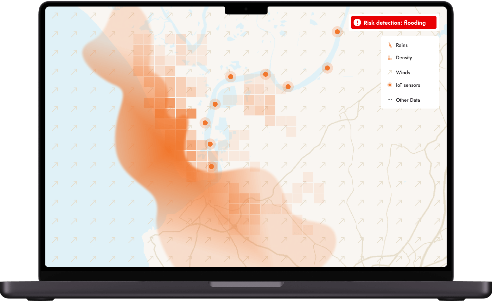
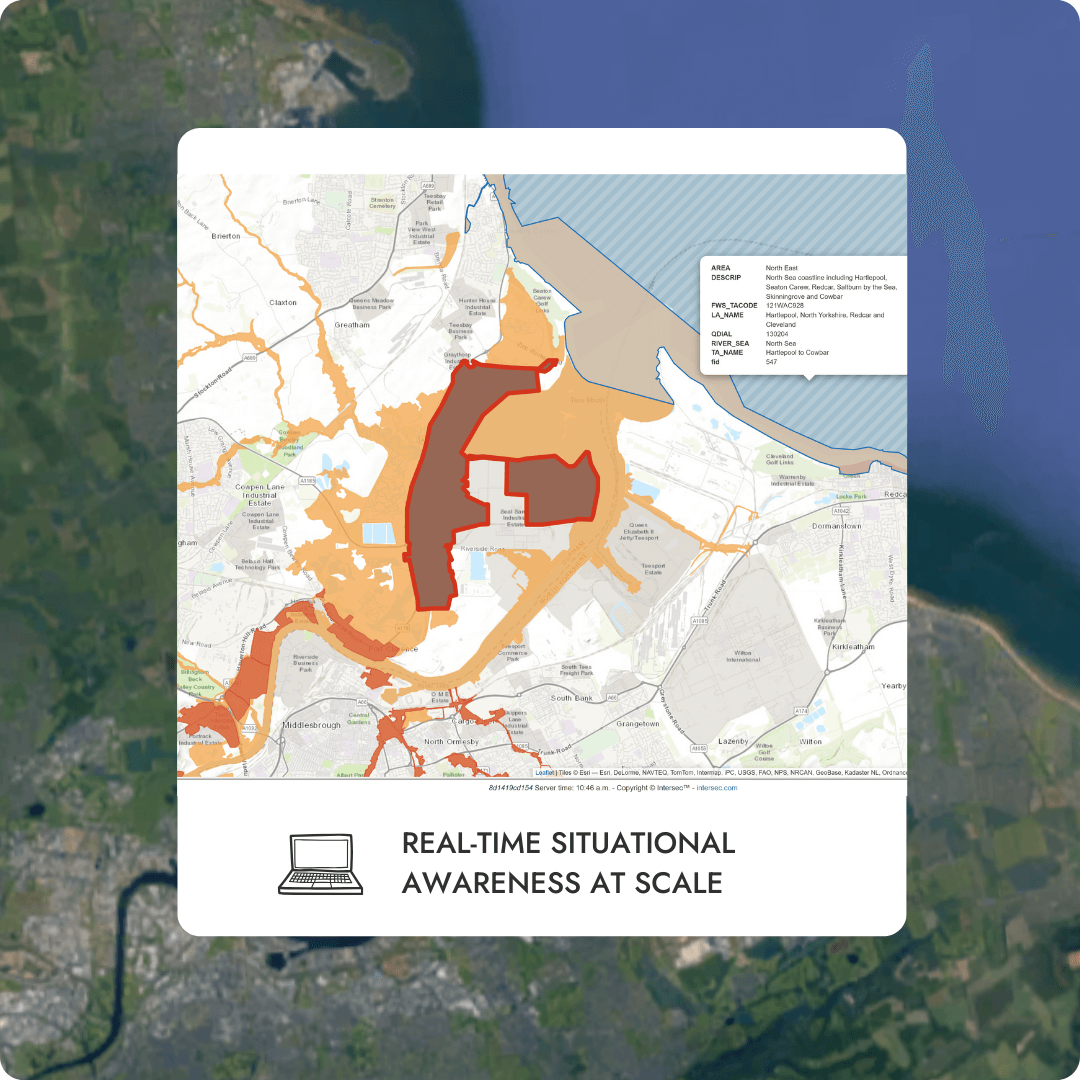
Real-time population heatmaps
moreThrough advanced algorithms, Intersec instantly computes and displays real-time population heatmaps to significantly enhance dynamic situational awareness, and triggers automated actions in line with each scenario ensuring swift and effective responses.
As the situation evolves, get tactical crisis management insights by visualizing live population heatmaps of the targeted area. End-users benefit from a rich cartographic vision of the terrain and the situation. With its embedded GIS capabilities, the solution smoothly integrates with external geodata sources and providers via typical standards from OGC (Open Geospatial Consortium) and IETF (Internet Engineering Task Force).
Field information, such as the alert location and the number of people receiving the message, is indicated in real-time, and, as the crisis evolves, changes in population density are displayed as colored-coded mapped zones.
Live data layering
moreBy relying on advanced location-based technologies, fast data capabilities, and AI algorithms, our platform consolidates key metrics enabling real-time insights into on-ground activities for local authorities, mission-critical sites, and critical infrastructures.
Intersec goes deeper into the data provided to you. On the map, one can add layers of constantly updated information flows to enrich the existing data of Points of Interest (POI): ambassies, police & fire stations.
This unified view and flexibility helps mitigate damage and downtime by restoring normal operations as quickly as possible.
Alert monitoring functions
moreMonitor threats around your stakeholders and facilities.
Make more adaptive and dynamic decisions throughout the management of critical events, and quickly protect or restore operations and infrastructures, mitigate brand and financial impacts, and most of all, help ensure employee safety.
Authorized collaborators can create alerts, define alert zones and select the preferred communication channels in a few clicks. The map page offers direct access to a toolbar for creating zones and manipulating sectors.


Featured content
E-book - Situational awareness for emergency alerts

.png)
Related use cases
Situational awareness
Our situational awareness instruments serve both authorities and private organizations by providing crisis managers with a real-time digital twin of the in-situ field situation.
Mass notification

Intersec provides a comprehensive, multi-channel application specifically designed for emergency mass notifications to enhance the reach and effectiveness of alerts for individuals at risk.
Incident response

In case of an incident, closely monitor ongoing situations and coordinate your communications with field agents and at-risk communities.
Emergency call location

Our emergency call location solution combines multidimensional cellular device locating capabilities to provide PSAPs with critical, certified, up-to-date location information, for all callers..
Get started with Intersec

Some of our prestigious clients


.webp)


.webp)