 Climate Change - Wildfires" />
Blog Series on Climate Change - #2 - Wildfires
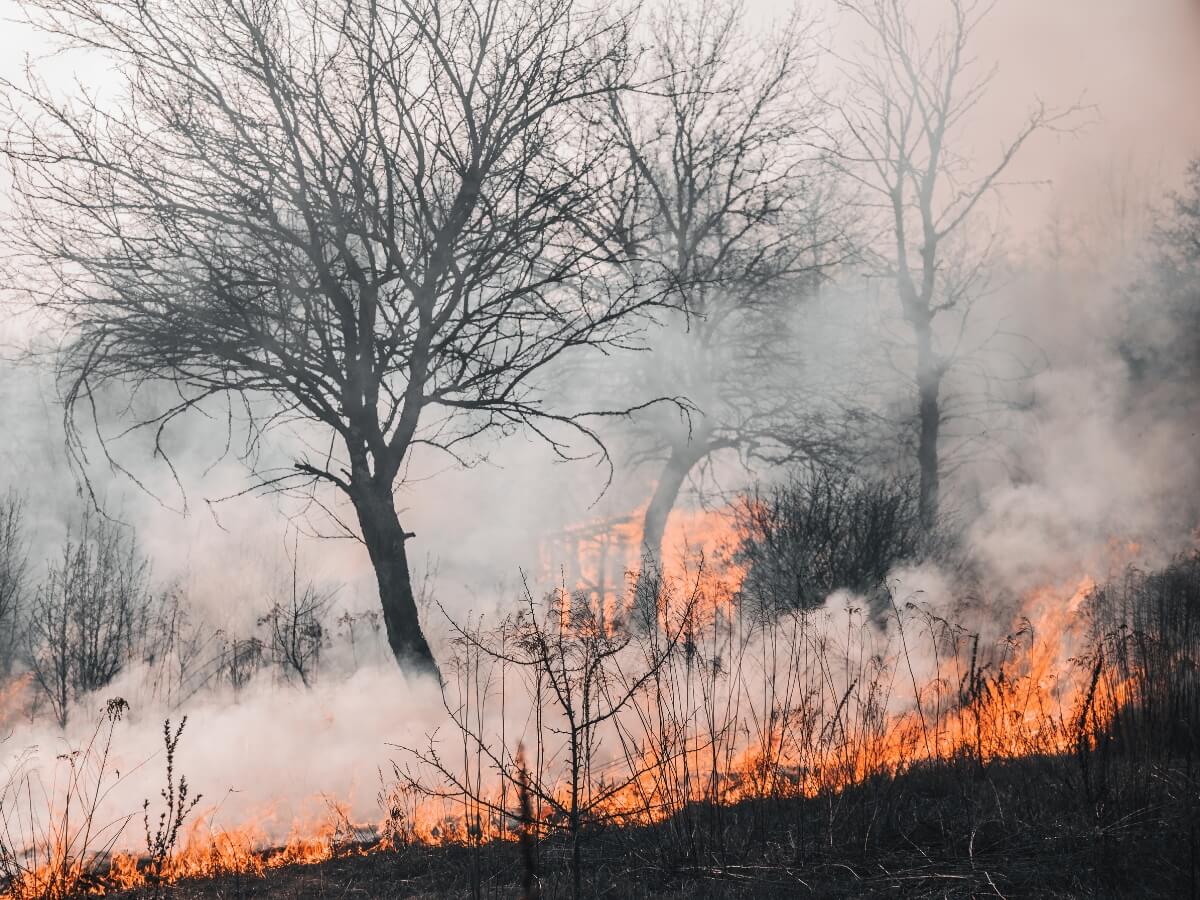
Fire season is in effect on all forestland. Fire alerts can be monitored in near real time via the Global Forest Watch interactive map, they are ongoing.
There is strengthened evidence that climate change increases the frequency and the severity of fire weather around the world. Climate change expert Niklas Hagelberg says a fast-warming planet will likely lead to more record-breaking blazes: “The planet is already 1.1°C warmer than it was in pre-industrial times and that is changing the world around us.” (source: UNEP). In addition to that, projections* indicate that the frequency of wildfires will substantially increase over 74% of the global land by the end of this century.
All over the world, emergency teams step up all efforts to strengthen their response to forest fires this year and into the future. Prevention, preparedness and emergency response are key elements in times of critical emergencies and disasters. We asked three questions to Mathieu Lafforgue, Public Warning Systems specialist at Intersec.
Q: To what extend can mobile alerts help authorities safe lives?
A: Fires can extend extremely fast and in an unexpected manner. Alerting the population as early as possible and in real-time, plus providing contextualized information as the situation evolves is critical. Wildfires are dangerous and stressful situations, in which people expect to be informed on a regular basis by authorities in charge. Targeted, useful, transparent, and regular communications help build trust between communities and governments. With the right tools, emergency response teams can send updates to the population on weather conditions, fire activity, evacuation warnings and orders, throughout the crisis. Last, when crisis is over, they can message people who have evacuated when it is safe to come back home. To reach the widest audience possible, three targeted mobile communication technologies are available, which can also be used in a coupled way: SMS Cell Broadcast, Location-based SMS and smartphone applications.
Q: Wildfires are unpredictable and spread quickly. What can response teams do?
A: PPopulations become more vulnerable to threats which are more diverse, sometimes less visible, and less predictable. Repeated communication to those who have not yet evacuated can save lives. Alerting those that approach an endangered zone and ordering them to turn around is also important. In certain circumstances, sending specific instructions to people located in a very targeted perimeter is possible with new technologies like device-based geofencing (DGBF) and subcellular geolocation.
Q: Can today’s technology facilitate the work of the first responders?
A: When wildfires occur, it is important that they respond in a timely manner. Crisis management solutions can help to visualize on rich cartographic layers the risks, the positions of assets and vehicles, population presence and so on. These solutions can be extended with live data feeds and propagation models so that rescue teams visualize in real-time how a fire progresses and anticipate how it can continue evolving, given meteorological conditions. In any case, coordination is key. The deployment of alerting technologies must come together with a well-defined public warning strategy, including preparedness trainings with communities.
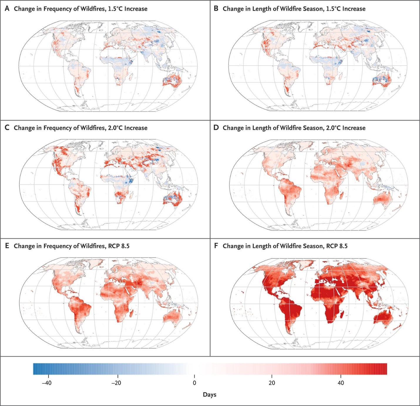
*Figure: The below figure displays the projected change from 1981–2000 to 2080–2099 in frequency of wildfires and length of wildfire season. (source: NEJM)
.jpg)
Editorial team
LinkedinThe Intersec editorial team is made up of professionals who share expert insights on AI-powered innovations, mission-critical communication solutions, and 5G location intelligence across civil protection, homeland security, and telecommunications.

Cell Broadcast Emergency Alerting live in 10 days
47 deployments. Four continents. Active conflict zones. We're not generalists who added public warning to a product catalog. This is all we do — and we're faster, deeper, and more adaptable than anyone.


.webp)


.webp)