 Location data platform | Intersec" />
Table of contents
- Telco data is valuable
- Location intelligence technologies
- Geolocation in 5G
- Promising use cases and progress
Telco data is valuable
THE ALTERNATIVE IN A POST-COOKIE LIFE
With third-party cookies scheduled to be phased out by 2023/24, marketers are searching for alternatives. While the prospect of a cookieless world has marketers searching for alternatives, CSPs can now compete on a level playing field with tech giants, since their data is more trusted. With climate change, natural disasters, and security threats of all kinds, CSP data can be used to help public authorities protect the population by alerting them more effectively and providing trusted location data for various use cases.
In 2016, the EU introduced the General Data Protection Regulation (GDPR), a law which would prohibit companies from collecting a user's data without their consent. By preventing tech giants from mishandling cookies and tracking data, GDPR opens new opportunities to use anonymized CSP data to gain contextual insights in a way that is privacy compliant.
The 'pseudonymization' required by the GDPR is processing personal data in such a way that the data can no longer be attributed to an individual without the use of additional identifiers, as long as these additional identifiers are kept separately, and technical and organizational measures are taken to ensure that they are not attributed to an identified or identifiable individual.
Anonymization removes any direct or indirect personal identifiers that could lead to a person being identified. Direct identifiers include a person's name, address, postcode, telephone number, photograph or image, or any unique personal characteristic. Indirect identifiers are bits of information such as workplace, postal code or medical conditions that can be pieced together to identify an individual.
While anonymized data falls safely outside the scope of the GDPR, the absence of identifiers limits the ability to derive insights from the data, and it can't be used for marketing or personalizing the user experience.
With the end of third-party cookies, marketers are searching for alternatives, and as privacy regulations continue to evolve, current marketing and communications tactics are at risk of becoming obsolete. Marketers can leverage email marketing lists; monitor social media engagement and use its analytics to capture demographics, but these are labor-intensive strategies. Businesses looking to leverage data while remaining GDPR compliant should look to communications service providers (CSPs), also known as telcos. CSPs collect vast amounts of highly detailed activity and mobility data from their subscriber base and they have invested heavily in building their network. This unique coverage of the territory and this unique access to a highly qualified user base gives them access to exceptional data that they can monetize provided they have the right tools. Thus, the opportunity for CSPs to provide data-as-a-service (DAAS) is one worth exploring.
WHY CSP DATA IS SO VALUABLE
CSPs have 100 % of both their subscriber base and their covered territory. Moreover, they can locate any device at any time within 10m accuracy in urban areas, conduct one location every three minutes, refresh the location on demand, and provide anonymized, reliable data. CSP data includes payment processing, and is not limited strictly to their telecommunications services, which allows them to create comprehensive, highly detailed customer profiles that can be used to identify demographic, geographic, behavioral, or interest-based patterns for hyper-targeted reach through selected channels.
CSP data can be used to:
- Gain insights and detect contexts in real-time to create stellar customer experiences
- Warn people before they enter an endangered zone
- Assist smart cities in dealing with heavy traffic
- Help outdoor advertisers gather reliable audience figures
CSPs, Wireless Service Providers, and other telecommunications service providers billions of Call Data Records (CDR) annually from mobile subscribers alone. Moreover, CSP data includes payment processing information, especially in prepaid markets, and the volume and variety of data increases dramatically if the provider offers landline and other services. This allows them to create comprehensive, highly detailed customer profiles that can be used to identify demographic, geographic, behavioral, or interest-based patterns for hyper-targeted reach through selected channels.
These massive data sets are known as big data. With the help of Location Intelligence, big data can be leveraged improve marketing effectiveness, enhance customers' experiences, and develop new sources of revenue.
Another type of big data is known as fast data. Fast data is real-time data that typically comes in from streaming and is analyzed in real-time to make rapid business decisions. It applies to Internet of Things (IoT) technologies, event-driven applications, marketing and advertising campaigns. It has proven extremely useful as well in public safety applications.
Activity data is anything done either online or in the physical world that can be recorded by computer, anything from using mobile phones to make calls, send text messages, or use data to browse a particular website. Collecting and analyzing these types of activity data is an important aspect of business intelligence, as the anonymized data can provide insightful information that can lead to profitable and actionable insights for telcos and their enterprise partners.
Two types of activity data worth noting are Detail Records (CDR) and x-Data Records (x-DRs).
- A CDR is a record of each time a mobile phone connects to a network when sending or receiving a voice call or SMS. A typical CDR contains the timestamp, call duration, caller and recipient identifiers, as well as the origin and destination of cell towers when the call between devices took place.
- x-DRs are the internet connection detail records generated when a device connects to a mobile internet. x-DRs only describe when the connection happened and the coordinates of the telecom antenna used to download the content, but x-DR data is usually more precise in terms of time.
Mobility Data is a record of the geographic location of a device during normal activity. The wide availability and use of mobile cellular devices along with the vast coverage of telecommunications networks makes CSPs rich sources of mobility data. Does the device owner work from home? Do they shop locally? If so, where, and how often? Do they workout regularly, and at what time? This type of data is extremely useful, as it can be mined for insights in a variety of use cases including transportation planning, smart cities, marketing, and more.
Trusted Data: Is your data trustworthy?
Trusted data (or authentic data) is information translated into a form usable by computers, whose source is verifiable — it can be checked through a standardized method to demonstrate accuracy. Data trust means having confidence that your organization’s data is healthy and ready to act on. Location data is considered ‘trusted’ when it meets the following criteria:
- Geolocation is captured at the mobile network level, unlike a GPS device whose firmware may have been altered to report a faulty position.
- It is generated by subscribers who have a contract with the operator, and who had to provide proof of identification to open their line, as opposed to OTT services on the Internet that require no more than a simple email address.
Location intelligence technologies
How geolocation is used to derive value from Big Data and develop more innovative service offers
Location intelligence adds depth and dimension to any data set, but in the telecommunications industry, applying location intelligence to activity and mobility data, and understanding where target customers live and work, how they spend their leisure time, and the ways they get to, and from their activities decides the competitive edge.
This process begins with geolocation. Getting geolocation involves a combination of various technologies that use geographical coordinates to pinpoint people, vehicles or, objects on a map. with GPS (Global Positioning System), the mobile or Wi-Fi position of a device, GNSS or an IP address.
Geolocation software allows us to collect and analyze massive amounts of raw telco data and structure it so that exploitable information such as visitor frequency, visitor profile, visitor paths, etc. can be extracted from it. By using geolocation tools that are based on Big Data, mass monitoring, and geofencing technology, massive volumes of telco data can be converted into an aggregated and anonymous stream of highly exploitable information about places, individuals, and times, quickly, and automatically.
Anonymized telco activity and mobility data becomes a rich source of aggregated statistics for business development that is:
- GDPR compliant
- At scale - Covers 100% of the whole population
- Fast - Delivers results in a matter of minutes, if not seconds
- Precise - Lacks the methodological biases of traditional surveys
- Easy to share with external systems
- Easily integrated into data warehouses
This process is not only the basis of our location intelligence platform; it helps to unlocks a multitude of opportunities for the monetization of telco location data.
WHY TELCOS MUST REINVENT THEMSELVES
The global location-based services market size accounted for $36.35 billion in 2020, and is expected to reach $318.64 billion in 2030, with the projected CAGR of 24.3% during the forecast period, according to Allied Market Research.
Among the factors driving this growth are:
- Due to data privacy regulations, cookies are scheduled to be phased out by 2023
- Increased spending on 5G infrastructure deployment
- High demand for mobile subscribers
- Rising demand for high-speed data connections
- The increasing number of OTT content platform customers
- A boost in digital media consumption and remote work figures
- The rapid increase in demand for high-speed broadband services for corporate applications
- The evolution of Internet of Things (IoT) equipment, technologies such as Artificial Intelligence and Cloud Computing and their application in sectors such as industry, health, energy, and public services, among others
- The expansion of wireless network coverage in remote areas and public places, such as airports, offices, government buildings, etc.
Telcos that can meet this increasing demand for connection and coverage without compromising on service quality stand to increase their market share, and gain a significant competitive advantage, but to achieve this, they’ll need detailed market share data, which can be captured through location intelligence.
⇒ Check out our whitepaper: Driving Business Value with Location Intelligence
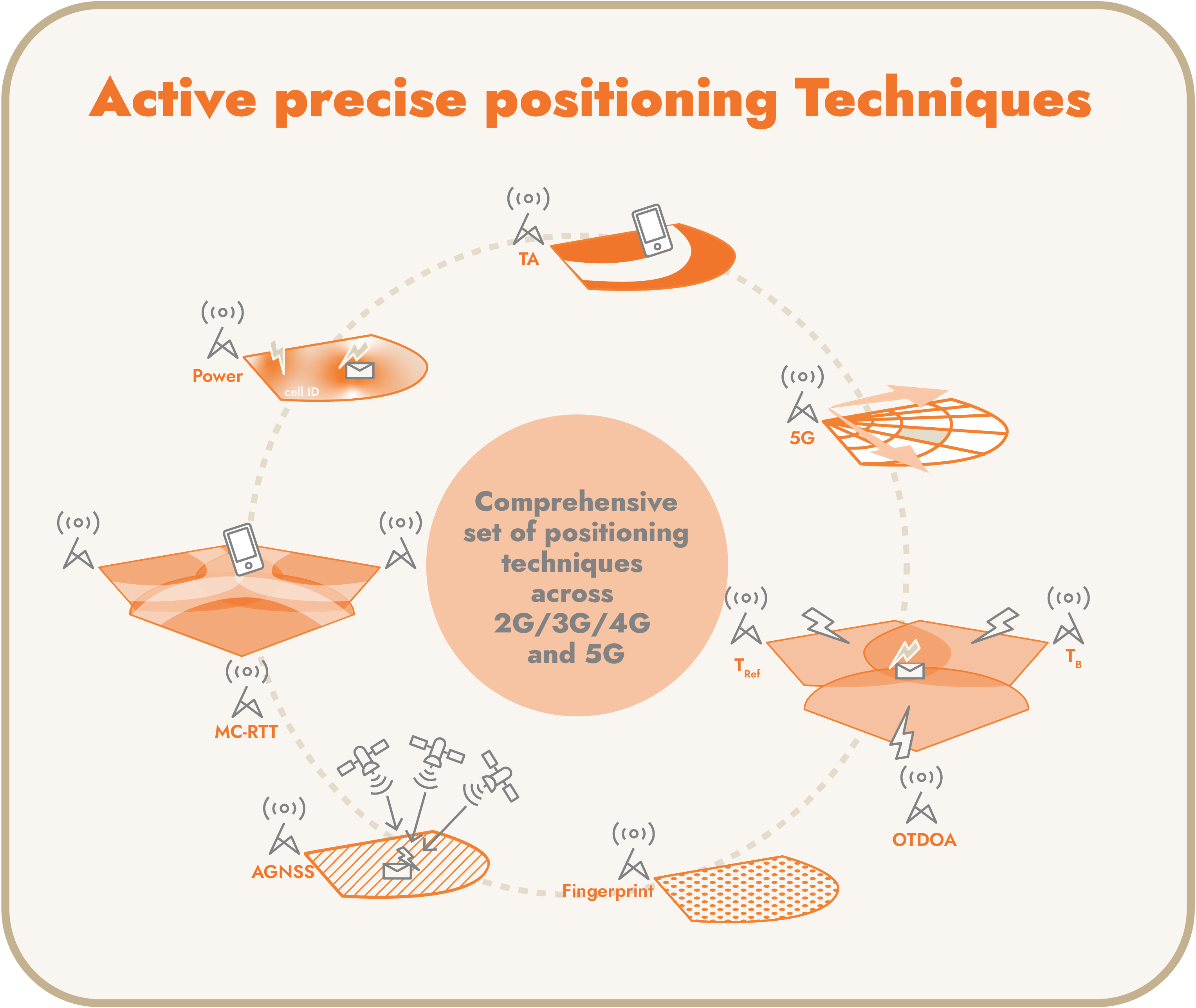
ACTIVE GEOLOCATION
On-demand geolocation
In the telco industry, subscriber geolocation goes hand in hand with providing core services such as calls and SMS. This type of geolocation is 'active' because it triggers specific activities on the network to retrieve a given subscriber location. In addition to tracking mobile subscribers, active geolocation is widely leveraged by mobile network teams at the request of law enforcement for tracking the location of identified suspects. The arrival of 5G in the market enhances location accuracy. With its use of millimeter waves and beamforming, 5G positioning achieves superior accuracy and allows a higher fingerprint resolution in the database.
Its key features are:
- Entirely device‐agnostic
- Unspoofable – resulting in extremely reliable information
- Provides instant refresh of subscriber’s location/undetectability of the location retrieval
- Cellular and subcellular accuracy
- Multi-measurements and triangulation
- GNSS-assisted location
- RF Fingerprinting
Still, this type of active geolocation has its drawbacks:
- Costly and limited scalability: Each query requires specific network activity, which limits the total volume of geolocation tracking. This type of location is also costly, and too many tracking requests quickly overwhelm mobile network capacity. This prevents the development of a number of use cases, including marketing (insufficient geolocation), geostatistical (requires large-scale analysis), and security (too costly). Network signalling is better used to provide connectivity to users.
- Easy to Evade: Suspects can evade surveillance by swap SIM cards and mobile handsets, or leaving their phones switched off unless necessary, and in such cases, active queries often fail to geolocate the subscribers.
- It also has several blind spots: Standard‐based active geolocation requires bilateral interconnections between operators’ geolocation equipment to locate roaming subscribers, and this architecture has not been deployed. It’s also impossible to track subscribers’ location based on their device identifier (IMEI). The system also assumes the targets (and their mobile number) are already identified and under investigation, and active geolocation can’t leverage historical data to explore and detect suspicious behaviors.
For geolocation to be successful, it needs to be accurate, and the location platform must provide the location information quickly. In wireless networks, positioning can depend on the mobility of users, the dynamic nature of the indoor or outdoor environment, and the nature of radio signals in that environment. However, whether a subscriber is in a rural or urban area, the same level of positioning accuracy is expected. In geolocation that originates from a mobile network, there is no single method that consistently provides a high degree of accuracy regardless of place or time.
- RF Fingerprinting: We conduct tests on a covered network territory that measure which cells the phones 'see,’ and at what strength. These signatures are stored in a database, and when we need to geolocate a mobile device, we ask it to return its reading of the radio environment, and based on this signature, we then search the database to locate the corresponding signature.
⇒ Check out our whitepaper: Higher location accuracy with RF Fingerprinting - Cell ID: Coverage area of the cell can be estimated and the ’mass center point’ of the coverage area is typically used as the UE location estimate. Cell ID/SAI locates the UE down to one cell and the cell location (antenna coordinates) and shape (from network planning) is known.
- Timing Advance (TA): Timing Advance gives the distance from the serving e/gNB with a known accuracy. In 2G the TA is based on the bit period of 1.67µs in GSM, which corresponds to 550m in distance. In 4/5G the TA is based on basic time unit Ts in LTE and is expressed in multiples of 16*Ts, which corresponds to 155m in distance. In GSM it is to compensate for propagation delay of UL bursts. In LTE/NR TA is used to synchronize UL with DL
- Round Trip Time (RTT): Thanks to larger bandwidth and relatively short chip duration in UMTS (0.26 μs), RTT measurements are more accurate than the resolution of the corresponding TA-based technique in GSM (∼550 m). In theory, a single RTT measurement can estimate mobile-to-base station distance within 131 m.
- Multi-cell RTT: In Multi-Cell RTT, the call flow is as follows: gNBs transmit DL PRS. The UE transmits SRS for positioning, measures UE Rx-Tx Time difference per gNB, and reports UE Rx-Tx measurements to LMF. Each gNB measures gNB Rx-Tx Time difference, and reports this measurement to LMF, which then estimates the RTT to gNBs, as well as UE positioning.
- Time Difference of Arrival (TDOA): The User Equipment (UE) measures the time of arrival (TOA) of signals received from multiple BTS, and the TOAs from several neighbouring BTSs are subtracted from the TOA of a reference BTS, and the result is the Observed Time Difference of Arrival.
- Observed Time Difference of Arrival: This positioning method measures the timing of signals received signals by using assistance data from the positioning server and using the resulting measurements to locate the UE in relation to the neighboring TPs.
- DL-TDOA - Downlink Time Difference of Arrival: Downlink Time Difference of Arrival is reported by the UE to the LMF, which uses it to refine the position of that UE.
- UL-TDOA - Uplink Time Difference of Arrival: The Uplink Time Difference of Arrival is reported by the gNB to the LMF.
- Power Level Measurement: The UE reports RxLev in 2G, RSCP - Received Signal Code Power in 3G, and RSRP - Reference Signal Received Power in 4G/5G, and the propagation model used in the planification tools converts these measurements into distance.
- DL-AoD: To determine the rture, gNBs transmit DL PRS across multiple beams, UE measures DL PRS-RSRP for each gNB/beam, and reports DL PRS-RSRP to LMF (up to 8 DL PRS-RSRP per cell), then LMF collects DL PRS AoD information from gNBs (i.e., beam directions), and computes DL-AoD based on DL PRS-RSRP measurements, followed by the UE location estimate.
- UL-AoA: To determine the Uplink Angle of Arrival, the LMF sends a positioning request to the serving gNB (NRPPa), which then determines UL SRS resources, configures SRS transmission in UE, and sends a response to the LMF (NRPPa). The gNB sends SRS activation to UE and the LMF sends measurement requests to serving and neighbour gNBs (NRPPa), which then perform measurements and report the results to the LMF (NRPPa).
- A-GNSS: In UE Based mode, the server sends a request to the UE to determine its position, and the server provides data assistance to aid in detection. UE assisted mode uses server to calculate positioning by making pseudorange measurements, while the server calculates the position.
- PPP-RTK GNSS Positioning: PPPO-RTK compensates for GNSS errors by taking precise satellite orbits and dock parameters, satellite signal biases from global networks of reference stations, and ionosphere and troposphere corrections.
PASSIVE GEOLOCATION
For a mobile phone to ring, mobile networks need to know where users are, at any given time, so network signalling natively carries location information.
The concept of passive geolocation is to constantly listen and extract this information.
Contrary to active geolocation, passive geolocation does not generate any specific network activity, which makes it possible to continuously track the location of every connected mobile, with absolutely no impact on network load.
Sending and receiving SMS or calls, surfing the web, receiving e‐mails, app synchronization with the network, switching the device on/off, etc., all carry location information. The high frequency of these events ensures a very fine tracking of all subscribers’ locations at any point in time.
Passive data collection works on any mobile networks (2G, 3G, 4G, 5G). It offers cellular and subcellular spatial accuracy for geolocation.
Its key features are:
- Device agnostic and full subscriber base
- Transparent from a user/network perspective
- High frequency of location reports
- Cellular and subcellular spatial accuracy
It’s important to know that passive geolocation is not a replacement for active geolocation. It complements it and brings the greatest value when combined.
Easily Locates Inbound Roamers
Inbound roamers are natively geolocated through passive collection, so passive collection can be used to unlock active geolocation queries on inbound roamer, without the need to query foreign networks.
Mobile‐Handset Tracking
Passive data collection lets you track individuals by on their SIM card, their mobile number, or by their terminal identifier (IMEI). Individuals can even be tracked without knowing their mobile number, based on their device. Moreover, individuals can’t evade surveillance simply by swapping SIM cards.
Fewer blind spots than active geolocation
In addition to inbound roamers and IMEI tracking, passive collection ensures no mobile activity goes undetected. As soon as a mobile connects to the network, even for a very short amount of time, this event is captured, and the location is updated. As an additional benefit, the last known location (of a missing person for example) is always available
Area monitoring and geofencing
Passive data collection can trigger instant notification whenever someone enters (or leaves) a predefined perimeter, making it a good option for protecting sensitive areas such as official buildings, international borders, and military facilities. Classical geolocation systems limit geofencing capabilities to a list of identified suspects, while passive collection enables notification on entry, based on filtering tools that differentiate authorised personnel from suspicious intruders. Thresholds can be set to notify authorities whenever abnormal attendance in an area is detected and, in the event of a specific threat or emergency, public authorities can monitor who is present in a specific area in real‐time. A contextual trigger can also be implemented to engage with the subscriber when appropriate.
Leverages historical investigations - Forensics
Passive data collection stores the continuous stream of geolocated events, which unlocks possibilities for future investigations, using additional analytics software. Historical records can also be used to build a retrospect of location events over the course of any given period. Given the frequency with which location events are updated, an individual’s path can be easily reconstructed and visualized.
Makes suspect identification possible
Suspects can be identified through their physical presence at past key incidents, frequent proximity to other persons of interest and mutual communications. These analyses can be enriched with different filters with the goal of reconstructing social circles that gravitate towards organizations. This process can be fine‐tuned and confirmed through the detection of suspicious patterns such as frequent swapping of SIM and/or handsets.
Understand the offline customer journey
Businesses can use offline analytics to gain actionable insights from the location or geographic component of data and better understand the offline consumer journey. Through analytics, brands can see what their consumers like, where else they visit, how they react to different types of messaging, and a multitude of other behavioral preferences.
Leverage IoT predictive maintenance
Offline intelligence also helps to detect anomalies through network data and trigger signals. For example, a vending machine is constantly connecting and disconnecting from the network: since the machine needs network connectivity to report a problem, it is likely that there is a problem and a malfunction in the overall system. Once the alert is issued by the platform, a technician can be sent to fix the problem. Location monitoring can be operated on a fleet-wide basis and works with any SIM card.
COMBINING ACTIVE AND PASSIVE DATA COLLECTION
The combination of active and passive data collection is extremely powerful. By combining the passive geolocation solutions that we natively developed 2009, with active geolocation technologies, we developed a Location Intelligence platform that provides comprehensive location technologies in both active and passive paradigms, with all capabilities delivered within a mutualized platform.
This has allowed us to enhance our unique geofencing capabilities, and develop methodologies based on algorithms that add value and provide invaluable information to telecom operators.
Why Passive-Active Orchestration Works
The purpose of passively collecting data is to gather huge amounts of information from a variety of different sources (Wi-Fi, mobile, sensors, etc.), without overloading the network with active queries.
The passive geolocation concept is underpinned by the principle of listening in to continually extract location information (events linked to a subscriber’s activity, such as sending and receiving SMSs, emails and calls, Internet browsing, synchronizing apps with the network, turning the phone on and off, etc.). The more frequently these events occur, the more precise the monitoring is. Why ‘passive’? Because passive data collection doesn’t generate any specific network activity. This method can be used to gather data both on traditional mobile networks (2G, 3G, 4G, 5G) and on Wi-Fi networks.
If, for example, a regional government wants to push a warning message to everyone who comes within a 100-meter radius of a fire; in passive mode, the real-time engine can locate subscribers at all times. If an event indicates that a subscriber is approaching the area of interest, an orchestration engine triggers active queries to obtain precise information in real-time. The closer the individual gets to the zone, the more frequent the active queries become, which ensures the exact moment when the individual enters the area is captured.
This kind of mechanism can be activated to boost the geofencing detection rate when the type and number of event sources, the geography of the target area, and the operator’s cellular network fail to offer a sufficient level of precision.
Our convergent approach
Intersec’s location platform is a 5G-ready, equipment vendor-agnostic platform that uses a combination of active and passive techniques to collect anonymized location datasets on a mass scale. It computes insights, detects pre-defined or machine-learned patterns in real time, and makes relevant instant actions and communications.
This solution combines traditional active queries with the passive collection of signalization traffic – retrieving the flow of signaling location data directly from the network. Orchestrating these two methods allows mobile operators to use the context that comes from passive geolocation to maximize the value of each active query. When an active query is made, it is no longer random, but to meet a specific need at a given moment of finer spatial or temporal precision. Our platform continuously locates millions of subscribers while actively polling the required ones, thereby avoiding extra load on the network. When used individually, passive and active location each have their strengths and drawbacks, but when used in combination, they enrich one another, which allows for more advanced features, and makes our location engine extremely powerful. This hybrid platform detects the use case and context, chooses the single most appropriate method, or combines them to benefit from their respective strengths. Our location engine collects 2,000 points per subscriber per day, compared to up to 100 when using traditional geolocation techniques.
This patented technology enables CSPs to:
- Increase location spatial and temporal accuracy
- Optimize network load
- Unlock new use cases such as an inbound roamer’s precise location
With our location platform, CSPs can leverage our location-based applications for Public Safety, Contextual marketing, Advertising, Smart Cities and IoT, unlock monetization opportunities with existing use cases, and seamlessly plug in any new and disruptive use cases.
HOW OUR PLATFORM WORKS
.png?width=700&height=1000&name=platform%20(2).png)
PUTTING OUR PLATFORM TO USE
Our innovative platform helps over 100 clients in 80 countries turn geodata into actionable insights for contextual marketing, geolocated advertising, public safety, smart cities, and the management of connected object fleets (IoTs). Below are some of its key applications.
Increase Public Safety
Our platform allows public authorities and telcos to work together to modernize their public alerting and crisis management systems, by leveraging situational awareness enriched by location intelligence. With our powerful tools, authorities can communicate with close to 100% of the population seamlessly, and through multiple communication channels. They can draw alert zones, broadcast messages in a geo-targeted manner, and send distinct messages to those entering or leaving a surrounding perimeter while viewing live field information such as real-time geographical distribution, dynamic population mapping, and network availability. No prior opt-in is required for life-saving cases.
Facilitate Lawful Location
Location Intelligence provides telcos with the tools necessary to comply with regulatory terms and satisfy Law Enforcement Agencies for advanced mobile tracking and investigations. Our disruptive technology extends common GMLC-based tracking to large passive geolocation tracing, and once mandated, provides access to real-time and past location history of subscribers and derives insightful information to help accelerate investigations. We can provide public authorities with access to location intelligence from mobile networks, through an effective, controlled, and user-friendly interface.
Control Epidemics
Our location platform gives telecommunications service providers and public health authorities the tools they need to spot risk cases, investigate outbreaks, communicate with the population in a targeted manner, support the enforcement
of protective measures and use analytics effectively to control epidemics.
Create Innovative Services
Imagine being able to interact with customers as soon as they arrive within a 50-foot radius of your business! Known as "geofencing," this real-time solution opens the door to a whole range of innovative geolocation services via APIs that are extremely easy for developers to use.
The Intersec platform’s query engine can place an operator’s entire customer database into a pre-established marketing campaign and provide high-performance solutions by creating complex scenarios in real-time.
For example, a retailer could target all the individuals between the ages of 30 and 40, who have used a specific number of gigabytes over the course of the day and send them push notifications of product news, deals and promotions, etc., as soon as they arrive within 1 km radius of your store.
This is the kind of information that marketing and advertising teams are eager to get their hands on to effectively target their campaigns.
Become A Trusted Advertising Channel
Location intelligence can help you manage highly accurate and personalized interactions with your customers by collecting activity and mobility data crossing it with CRM data.
Our platform is device agnostic and provides mass-scale geolocation of your customers, and advanced geofencing mixed with trait-making algorithms. It allows users to Send personalized, rich-media messages, social media and instant messaging apps, personalize communications to each sub-segment and chatbots, and create campaigns in a few clicks.
⇒ Check out our whitepaper on location-based advertising (LBA)
Upsell Mobile Subscribers
Our platform helps telecommunications service providers boost revenues derived from subscriber roaming activities by enabling contextual engagement before, during, and after their journey abroad.
Enhance Your Business Intelligence
When used as a business intelligence tool for the telecommunications industry, location intelligence can help you:
- Identify possible problems within cellular networks
Detect when certain network components being under- or over-used, or act as a substitute for a mobile operator’s central database to prevent overloading. It can also flag up cells that are not up to date: if a subscriber’s phone is connected to an antenna, coupling the information with Wi-Fi or GPS data can help the operator realize that the subscriber’s phone has switched to a different antenna, several kilometers away. - Flag Fraudulent Activity
Operators can instantly detect abnormal traffic generated by cloned SIM cards and disable the line immediately. Prepaid SIM cards purchased using a false identity and used to call premium rate numbers overseas are flagged to the local operator in a matter of minutes, whereas previously it could have taken weeks, resulting in huge financial loss.
Moreover, our location intelligence solutions can be seamlessly integrated into traditional IT architectures, enriching them with new features.
Future-Proof Your Smart City
Metropolitan areas continue to grow exponentially, so why not apply Location Intelligence to make the most of the mobility data stream? LI can help you anticipate needs, detect changes in behaviors, and learn from past events and crises. Our solutions can help you control traffic jams, energy waste, and pollution and keep your citizens safe. We can also help you track tourism trends, and analyze movement patterns to understand commuting behaviors
Our Smart Cities solution features:
- Device-agnostic passive collection
- Opt-in-based geolocation enabled alerting and info stream for locals
- Live information and alerting for visitors, through many digital and standard channels during sporting and cultural events
- Detection of abnormal situations via machine-learned aggregated density surveillance
IoT – Manage Your Fleets
Turn a simple SIM card into a smart passive KPI collector and accurate geo-localizer for small devices. Moves and stops in fleets are tracked and stored for future reference. With collected geodata, you’ll be able to derive statistics and behavioral models.
You can also:
- Set up user alerts on forbidden or abnormal behaviors
- Monitor communications, consumptions, and relevant metrics (connected cars, etc.)
- Track when and how failures happen and troubleshoot in a snap
⇒ Read our blog post: Mass-scale location-based services: 5 tips for choosing the right partner
Geolocation in 5G
GEOLOCATION AND THE 5G ROLLOUT
Four generations of wireless technology have evolved from enabling the use of car phones to text messaging, and from smart phones to streaming music and video on the go, and many of the connected devices we use today. The fifth generation of this technology, (5G) is the latest global wireless standard and is among the fastest and most robust technologies the world has ever seen. Its higher multi-Gbps peak data speeds, faster connectivity speeds, ultra-low latency greater bandwidth and reliability, and massive network capacity, lead to quicker downloads, and much lower lag. Moreover, it maintains consistently high data rates—even when users are moving around, resulting in a much more uniform user experience. 5G can also provide greater network capacity by expanding into a spectrum such as mmWave.
The speed, connectivity, and performance of 5G opens the door to a network that empowers new user experiences, and has the potential to connect industries, people, vehicles, and devices. As new technologies emerge to leverage the benefits of 5G, the opportunities for telcos will increase.
⇒ Check out our eBook: Geolocation in 5G is driving a shift for CSPs
5G New Radio Frequency bands and mmWave
Since its initial rollout in 2019, the mission-critical capabilities of 5G, such as superior speeds and low latencies, have increased the number of use cases as well as the demand for data and performance.
At the start of the 5G standardization process, certain requirements for availability, latency and reliability were identified to provide connectivity for services with extreme requirements:
- 1,000 times higher data volumes
- 10-100 times more connected devices
- 10-100 times higher typical user data rates
- Five times lower latency
To meet the need for enhanced data and performance, 5G radio frequency ranges were widened. They now include all those previously held by 4G, as well as more frequencies up to 6GHz (Sub-6) and the high band (mmWave) spectrums. However, as data consumption rises, the Sub-6 5G capacity could run out in mature markets. This would make 5G mmWave a valuable resource for the continued offering of enhanced mobile broadband services.
Frequency bands used in 5G NR
In 5G NR, service providers use a combination of radio frequencies to deliver high-speed data services to the end users, with the help of 5G frequency bands that possess different capabilities with regards to speed and range.
5G low bands deliver 5G coverage over the longest distances
Low-band spectrum makes it possible for operators to provide broad coverage but with speed and latency that is only incrementally better than with 4G networks, depending on your proximity to the cell site. However, low-band spectrum does make it easier for the wireless signal to penetrate windows and walls.
5G mid-band spectrum combines coverage and capacity
Mid-band spectrum is in the 1 GHz - 6 GHz range and can carry a high volume of data while travelling significant distances, which makes it ideal for 5G.
5G high bands (mmWave) Ultra fast-short distance
At 24 GHz band and higher, the millimeter wave spectrum is very high on the spectrum chart. Millimeter wave spectrum signals can’t travel very far and are susceptible to interference from things like trees and buildings and even glass. The advantage of millimeter wave spectrum is that if the signal is unencumbered, users can get connection speeds between 1 Gbps to 3 Gbps or even higher.
What makes 5G mmWave unique
With 5G, high bands above 24GHz can be allocated for telecom infrastructure as long as regulators have freed up spectrum for use by service providers. Spectrum allocations for mmWave are often extremely wide, offering upwards of 800 MHz per service provider and band. This enables the network to deliver high capacity and improve its handling of peak rates. Wide radio carriers are required for the high band to be used within wide spectrum allocations. These wide carriers enable shorter transmission time intervals and lower radio-interface latency, making it easier to introduce and support low-latency-sensitive applications.
The limitations of mmWave: Weak penetration and an ultra-short range
mmWave 5G networks are ultra-fast, but they also have an ultra-short range and weak penetration. mmWave's performance can be affected significantly by doors, windows, walls, trees, vehicles and even humans. The density of base stations required to satisfy the quality of user experiences will be decided by the constraints of blockages and latency, rather than the requirements of coverage or capacity. Whereas 4G networks require 8-10 base stations per km², 5G networks would need as many as 40-50 base stations per km².
5G Infrastructure rollout - A Wealth of Opportunities for CSPs
5G will enable CSPs to use anonymized data as a service and tap into new markets:
- Innovative marketing campaigns
- Public Safety
- Lawful Location
- Epidemic Control, and more
Our scalable and future-proof and vendor agnostic platform allows CSPs to:
- Fully leverage top-of-the shelf location-based applications
- Unlock monetization opportunities with existing use cases
- Seamlessly plug in any new and disruptive use cases
Ensuring subscriber security
According to telecommunications giant Ericsson’s June, 2022 Mobility Report, 5G will account for nearly half of all mobile subscriptions by 2027. 5G opens a wide range of new applications for consumers businesses and industries, and CSPs must be able to ensure confidentiality, data integrity, accountability, and availability with their service offerings.
5G standards have addressed privacy issues right from the beginning, and the first release of 5G already has many important privacy features. Coincidentally, the 5G standardization release plan took place in the same year that the GDPR launched its regulation to harmonize personal data protection laws across the EU member countries. Given that Big data, which often contains personal data, will be at the core of 5G, protecting personal data will be crucial for adopting 5G.
CSPs need a robust strategy to protect their networks from known security risks and it is recommended that they add advanced analytics to their existing strategies to raise their level of security protection even further.
Modern security monitoring and analytics tools can reveal known and new security risks, allowing CSPs to take pre-emptive action and implement the necessary countermeasures before their networks become subjected to attacks. Regular assessments make it possible to continuously identify potential security risks and verify the measures that protect against them. The results from security analytics should be integrated into the security risk assessment to turn unknown security risks into known ones.
Learn about our solutions for effective data governance and consumer data privacy.
5G SCALABILITY AND ADAPTABILITY
5G will be able to scale and adapt to a complete spectrum of use cases such as providing uniform, fiber-like broadband services everywhere and ultra-reliable, mission-critical services such as controlling the power grid or remote medical procedures, while supporting billions of ultra-low energy devices that require expansive coverage, at very-low data rates and at ultra-low cost.
Connect more devices
With the number of devices that connect to the network increasing year over year, the ability to connect more devices simultaneously is crucial. 5G intelligently transmits to each device and can handle as many as 1 million devices per square kilometer.
Connect more types of devices
5G is designed to connect a greater variety of devices than just smartphones. As new types of connected devices with different levels of performance and characteristics are developed, 5G will be able to adapt, providing connections that consume very little energy for smaller devices, while providing extremely fast stable connectivity for industrial devices as required, unlike 4G, which provided single-size connectivity, that gave every device the same service.
How fast is 5G?
The size of a frequency band determines the amount of information radio waves can carry, and once that limit is reached, increasing speed in one area means speed will be reduced elsewhere. 4G improved data compression and added new frequencies, but it loses capacity in crowded spaces. 5G frequencies and technologies add 10x more capacity, allowing for multiple devices to receive higher data speeds simultaneously.
Data traffic increases every year as people stream more video and use more connected services. 5G was designed to provide more capacity for social media, video streaming and other things we are already doing today, but also for new innovative use cases such as securely streaming high-quality video from an ambulance to the hospital and enabling a range of new types of smart devices and industry digitalization.
5G Advanced: High-Precision Location
In April 2021, the 3rd Generation Partnership Project (3GPP) revealed 5G Advanced, which is another name for the upcoming Release 18 -- and future releases -- of the latest 5G cellular specification. The high speeds, low latencies, and enormous capacities of 5G networks make information available to us instantaneously. With 5G-Advanced, the network will be able to locate objects within a few centimeters and provide timestamps to within a few hundred nanoseconds.
5G-Advanced will have new, integrated, state-of-the-art positioning technology that will bring reliable positioning accuracy down to the sub-10cm realm without supplementary beacons, or reference to satellites. Satellites are the cornerstone of GPS technology, which can provide accurate positioning outdoors, however, their signals can’t penetrate indoors, making them unable to facilitate the super-accurate positioning needed for indoor applications.
To provide this high level of positioning accuracy, 5G-Advanced is expected to use a technique known as “carrier phase positioning,” whereby the phase of the radio-frequency carrier signal transmitted by the base stations is measured and used to fine-tune the position estimate down to a tiny fraction of the signal wavelength. This technology has been tested outdoors using satellite signals, but with 5G-Advanced, carrier phase positioning will be applied to local base stations for the first time.
"This means that devices connected to a 5G-Advanced network will be able to access the same level of positioning accuracy regardless of whether they are indoors or outdoors – which is ideal for dedicated logistics networks at ports and airports, as well as for public safety, lawful location cases, and marketing campaigns. The ability to maintain super-accurate positioning in all locations will also be hugely advantageous for vehicular applications, as accuracy and safety can be assured even in tunnels, far out of reach of satellite signals". (Source: Nokia)
Promising use cases and progress
Intersec’s industry-focused products convert geodata into actionable insights in the fields of public safety, contextual marketing, geolocated advertising, smart cities, and the management of connected object fleets (IoTs). We provide platforms and services to CSPs around the world, be they home broadband companies, mobile operators, or cable providers, and our unique big data platform can be activated for a multitude of use cases. Our 5G-ready geolocation platform accelerates positioning use case enablement, read the press release to learn more.
⇒ Check out our webinar: Geolocation in 5G: technological landscape and promising use cases
ENHANCED BUSINESS INTELLIGENCE
Get to Know Your Customers
Information generated by geolocation gives businesses the opportunity to learn more about their customers’ lifestyles, travel, and spending habits. This is a smart business strategy, not just for Telco operators but for all the other sectors to whom the processed data is then sold. It provides a wealth of monetizable that would appeal to firms who need to identify different profiles to target a communications campaign more effectively, or simply gain a better understanding of its customers’ needs. Customer insight helps build stronger customer relations, drives customer loyalty, and allows offers to be tailored to the individual.
Improve the quality of your network
Data gleaned from a mobile network can help Telco operators identify possible problems within their cellular networks. It can highlight traffic peaks in specific cells on specific days of the year or detect customer connection problems. It can also flag up cells that are not up to date: If a subscriber’s phone is connected to an antenna, coupling the information with Wi-Fi or GPS data can help the operator realize that the subscriber’s phone has switched to a different antenna, several kilometers away. Operators can use all this information to guide their decisions about network and antennae roll-out, all at minimum cost.
Identify and stop fraudulent activity
Using geolocation solutions, operators can instantly detect abnormal traffic generated by cloned SIM cards, or prepaid SIM cards that are purchased using a false identify and then used to call premium rate numbers overseas. These types of abnormal activity are flagged up to the local operator in a matter of minutes, and the lines are disabled immediately, whereas previously it could have taken weeks. Super-speedy and highly responsive, today’s new geolocation solutions can consequently help operators be more competitive, and can be seamlessly integrated into traditional IT architectures, enriching them with new features.
HEALTHCARE
Stop the Spread of Infection
Effective hand hygiene is one of the simplest and most important measures of infection prevention. Healthcare facilities can use Location Intelligence to monitor hand hygiene compliance by tracking the usage of soap dispensers, including when staff approach the hand hygiene station, whether they use the soap dispenser, and the amount of time they spend in the zone surrounding the dispenser. The hand hygiene data gathered can be combined with staff positioning, to determine if staff have been exposed to infectious diseases such as COVID-19 or other influenza-based viruses in locations where they have been.
The University of Fukui Hospital in Japan implemented a location-based system that monitored the hand hygiene of its staff, as well as their real-time distances to patients that increased the number of times medical staff performed hand hygiene measures while attending to a patient by more than 300%.
ASSET TRACKING AND MANAGEMENT
The expansion of IoT applications across different industries opened a new door of opportunity for CSPs. and we have a solution that allows telecom operators to enhance their IoT offerings by adding the location component to the different types of IoT devices. Through the regular interaction of the devices with the operator’s network(s), GeoHub enables CSPs to extract the location information for IoT devices in real-time, regardless of the availability of GPS functionality on these devices, enabling a multitude of additional use cases including fleet management, asset tracking, and telematics among many other applications that translate into new revenue streams.
Monitor and Track Devices With or Without GPS
If an asset with a CAT M1 IoT device (no GPS functionality) is being moved from California to Virginia, the IoT device would periodically sends information through the Operator’s network before going back to sleep to optimize power consumption. In each interaction, GeoHub would extract the serving Cell ID, translate it to its coordinates and store it in the database as the last known location of the device/asset. As the asset moves through the network, each new location is passively extracted, requiring no additional signaling from the network or the IoT device beyond the normal periodic interaction. As the “last known location” is updated, it creates a historical log that enables the end-user to query the location of the asset at any given time. Our solution can also provide additional insights about the time of journey, distance traveled, and average speed of movement.
If the same asset being moved from California to Virginia has a CAT 1 IoT device with GPS functionality, the device would be configured to only provide GPS location when the asset is close to its destination. With GeoHub, a virtual geofence could be created around the destination, and the IoT device would be triggered to provide the GPS location once the asset is detected within the geofence. This ensures optimal power consumption while still benefiting from the accuracy of GPS location for the designated time period.
Network-originated passive location can also act as an additional safety measure to GPS location due to the unspoofable nature of network interactions as opposed to the GPS module which can be hacked to report false coordinates.
Fixed device monitoring
Smart devices such as thermostats, parking meters, vending machines, utility meters that are meant to remain stationary are implemented with low-power chipsets with no GPS functionality, however, displacement of these devices can easily be monitored with the help of the passive location data collection and the Personalized Geofence (PGF) feature in GeoHub. Once a device is installed in the intended location, GeoHub would automatically retrieve the location of the device and set it as its new PGF. This provisioning process can be performed on hundreds of millions of devices simultaneously, in a matter of seconds. The devices would be monitored continuously, and the end-user would be notified of any movement outside its provisioned location.
SMART CITIES
Location intelligence can have a positive impact on several aspects of smart cities from real estate development to traffic and transport management, to crime prevention, and more. Our solution can reveal variations in foot traffic in a defined area, the routes most commonly by cyclists, pedestrians, cars, and buses, changes in citizens’ activity and mobility. Location intelligence can also segment visitors by type (workers, tourists, residents) and allows you to anticipate needs, learn from past events and then implement changes that will enhance almost every facet of a smart city’s services. Cities and tour operators could accurately determine the number of buses and taxis to minimize queuing, recommend specific routes for tourists to better navigate and enjoy the city, and push tailored information during specific events such as traffic jams, rain, etc.
PUBLIC SAFETY
By providing real-time intelligence based on telecom data to local authorities, our AI-powered and 5G location-fueled platform enables emergency services to:
- monitor population flows,
- establish a geofence around a designated area,
- analyze the presence of individuals in hazardous areas,
- communicate relevant instructions to all mobile-equipped citizens instantly and efficiently, using location-targeted A2P SMS
- adapt resources according to the situation with the help of continuous real-time data aggregation
Public Alerts and Crisis Management
Being adequately prepared for a crisis requires a strategy aligned with the nature of the potential disaster, the size of population it will impact and the timeframe during which it occurs (discussing the need for a strategy that aligned to the nature of the disaster, how big a population it will effect and the timeframe over which it occurs, the strategy must also include the timing, nature and content of public alerts and follow up messaging, as well as the timing and duration of geofencing to handle displaced populations.
We offer a specialized software suite for crisis management and public alert requirements that addresses both the needs of public authorities, and the special needs of telecommunications operators involved in the global public warning architecture at national or regional scale.
Public Warning Suite (PWS)
Our public warning systems (PWS) enables public bodies to locate and target multiple mobile subscribers ranging from small groups to an entire country that use 2G to 5G devices, disseminate a message via SMS, integrate with GIS, and build a geofence around the endangered zone in seconds. Predefined locations, ready-to-use target groups and pre-formatted messages allow officials to act quickly, and feedback can be monitored in real-time, thanks to live KPIs.
Crisis Management
We have modernized crisis management by combining multiple communication channels and live situation awareness capabilities. Our solution allows you to create alerts with just a few clicks and provides options for Multiple types of alerting campaigns including post-event communication. It also displays real-time anonymized population density and alert broadcast information feedback.
Telco Solutions for Public Safety
Our carrier grade cell broadcast center and location-based SMS public warning system is designed to ensure mobile network operators can fully meet regulatory needs for mobile public alerting. By leveraging the big data capabilities of our Intersec platform, our system will allow you to quickly compute geofences around endangered areas, estimate target size and SMS diffusion duration, and address locals and inbound roamers, in their own language, in seconds, and at scale.
Emergency Call Location and Routing
Emergency calls require telecommunications operators to identify the caller’s location quickly and precisely, so that it can be accurately routed to the Public Safety Answering Point (PSAP) at scale. Another critical function of the original telecommunications operator is to report certified and most accurate locations to be used in dispatching and guiding emergency units to the exact site of the incident. Our emergency call location solution combines multidimensional cellular locating capabilities to provide emergency services and first responders with critical, up- to-date information, allowing them to save more lives. Moreover, our location intelligence expertise has been leveraged as a complement to the Advanced Mobile Location technology when blind spots occur.
.jpg)
Editorial team
LinkedinThe Intersec editorial team is made up of professionals who share expert insights on AI-powered innovations, mission-critical communication solutions, and 5G location intelligence across civil protection, homeland security, and telecommunications.

Market Outlook: Hot Topics in the Telco Industry
Discover how telecoms can lead the AI revolution
From predictive maintenance to smarter customer support, AI isn’t just hype, it’s transforming core telco operations. Find out how the latest breakthroughs are reshaping the industry.


.webp)


.webp)